There’s a fork from one year ago, CoMaps, that is gaining different features
E.g., I am adding CarPlay Dashboard support that you can test by joining the TestFlight
We are in great need of both more testers and some proper iOS devs (I am not). We’re racing to get scene lifecycle support by September, perfect opportunity if you like modernising old codebases!
We're this on https://cartes.app, trying to push the Web further (even on mobile devices) so that you don't even need an app for most use cases.
Ah, the same people who I bought Maps.Me from in 2012 - that when I went to use it recently now bombards me with "sale ending in 4 hours!" pro subscription ad popovers in order to restore functionality (more than 10 offline map areas) that existed at the time I bought the app? No thanks.
It's also very easy to edit some basic data through the app so if you notice an error in the map it's usually possible to fix it right there and then.
I frequently use it in the airplane without WiFi and wish to have high definition, but downloading country by country is too cumbersome.
I've wanted to run it on my wear OS watch, but while you can sideload the APK, wearOS does not have a file browser, so it's not possible to import a planned route or similar. Has anyone here any idea for how to solve this?
Edit: didn’t know about the ads / proprietary server issues. I guess this is the only sort of place to find out unless users are browsing the GitHub repo.
There is still a super long way to go until it suits everyone's needs, but the end + even further is starting to come into sight.
What I absolutely can’t stand is the routing. It once tried to send me through residential Oakland on some Manhattan-grade staircase labyrinth instead of just taking normal streets.
> TilelessMap is an open, offline-first mapping engine designed for critical field use, such as forestry, emergency services, and humanitarian work. Built with C and optimized for mobile performance, TilelessMap enables full local map rendering without relying on cloud infrastructure — even in areas with poor or no internet connectivity.
They have an Android app with maps of Yellowstone, Sweden and Norway.
https://play.google.com/store/apps/details?id=org.tileless.m...
We ended up taking screen shots of Google Maps where we zoomed in on local streets, on an ad hoc type atlas. I wish we had this app back then
I've had Maps.Me on my phone for some years; it's often not as accurate or polished as the commercial offerings (Google, Here Technologies), but it's pretty nice. What might make me switch?
Looking forward to iOS support so more people can use it.
Anyone has context on the following not hidden over Git-* issues (I was left thoroughly confused trying to understand it)?
Maybe the data could be shared/distributed via hypercore or similar.
I find heatmaps are my primary way of finding new mountain biking trails and routes.
Do there exist apps that share their offline map data? As in: install app A, dowload offline map data for country xyz, use in app A, install app B, use same map data in app B (or C, D etc) without re-downloading the map data?
As I understood, that was not the case as each app uses its own format which is some underlying public geo info (presumably too big to have on device), filtered / processed in per-app fashion.
The sillyness & waste of this is obvious. So: any progress in resolving this situation?
Example: a modern mid-high end phone can contain this, a complete copy of Wikipedia, and a small LLM capable of understanding natural language queries and using tools. All on board, no connection needed.
Plus it an also carry most peoples' complete music and book collections and a meaningful chunk of most peoples' movie collections.
A mid-high end laptop can carry all of it and then some. Laptop and desktop storage is gigantic by previous generation standards. Mine is a higher end laptop but has 8TB storage. 512GB to 1TB is mainstream.
CoMaps forked out of OrganicMaps after a row about money
I'm working on https://cartes.app and we're well aware that search is not on par, far from it. But we have hundreds of other features and bugs to fix. https://codeberg.org/cartes/web
How so? GPS is like FM radio: you send nothing, you only receive.
Apps like organic maps or comaps let you use the maps fully offline and you can compute itineraries without GPS when your need this (from point A to point B, with as many stops as you wish).
I strongly recommend you to seriously look into comaps or organic maps if you don't know them.
Now, "GPS isn't working or depletes my battery, what do I do?" is an interesting topic worth looking into. It seems you are trying to automate what we all do when GPS doesn't work well. I find that relatively easy in a city, not so much in a road on the countryside.
But then, it of course isn't Google Maps. It is likely to be more out of date and will not understand "natural" search queries as Google does. I believe it just takes some getting used to. There is overlap between the two, each service has its strengths and weaknesses, but also unique features.
The reason it moved to the internet was not that it wasn't possible to stay offline-first. If the app depends on your server, then the owner can monetise that (e.g. with subscriptions) or track the users. It is more interesting for companies than allowing the users to buy a snapshot of the maps once and never come back.
Offline-first nowadays comes from open source projects, not from companies.
In my country, the typical laptop purcase from a retail chain is still 512GB or so, and moreover, few and fewer people own a laptop since it is becoming normal for a smartphone to be one's only computing device outside the workplace (even uni students are foregoing "real computers" now). Anything more than such a basic laptop is a premium product, and premium products cost premium prices.
The hardest thing about any effort that is two or more people is the interpersonal, coordination, consensus, and organization aspects. Everything else is easy in comparison.
Until you realise that there is not one true way to show a map, and that different apps may actually have different needs. Suddenly it becomes obvious that not all apps can use the same shared offline data.
1. Address lookups. Many of the buildings in OSM have yet to get street addresses added, so navigating to an address is a bit hit or miss. This gets fixed with time as people update the maps and wouldn't be a show stopper.
2. Real time traffic and detour navigation. This is really needed when navigating around busy cities where a wreck on a major highway can result in significant delays. This needs a combination of an external service (separate from OSM) but also one that has enough adoption to have usable data.
I've been using Organic Maps for almost 3 years. I lived in Chicago during this time, as well as some smaller American cities. I go back and forth between Organic Maps and GMaps depending on the situation.
I've found that Organic Maps' lack of traffic data isn't a big deal for me. It doesn't always give you an accurate ETA, sure, but it isn't any worse at actually getting you to your destination.
The thing with GMaps is that everyone has traffic data, so nobody has an advantage. Google's alternative routes end up equally saturated as the main routes, meaning a "dumb" maps app that always takes the main route will get you to your destination in basically the same amount of time. This is backed up by my own personal experience, and some academic research [1].
Now, when I do need an accurate ETA, I go back to GMaps. I'll also use GMaps to route to businesses sometimes, because OSM doesn't have up-to-date info about businesses throughout most of middle America.
Google Maps will always have better POI data because they have a larger userbase and they've gamified adding POIs with the "Local Guides" badge.
The main reason to switch is to have an offline-first experience. Google Maps does not provide offline maps everywhere, e.g. South Korea. And if you've ever tried using the Google Maps app on a weak connection, it's frustrating because it still tries to download remote tiles instead of using the ones you've downloaded.
Lastly any contributions you make in OpenStreetMap will show up in Organic Maps / CoMaps for everyone.
Personally, I use Google Maps on a daily basis, but have Organic Maps and regions downloaded for travel and just switch between the two. It's good to have a reliable fallback.
Maps are so often done as native apps that to my knowledge no one tried to just use the PWA capabilities to cache tiles on the Web. Of course what's hard is cache invalidation. Does the user want to update the tiles ? Never ? Daily, weekly ? Only some regions ? Or manually ?
Here's an issue about that : https://codeberg.org/cartes/web/issues/1078
It's in French, unfortunately Codeberg has no auto-translate capabilities yet.
https://itsfoss.com/news/organic-maps-fork-comaps/
> Despite being advertised as a community-driven project, key decisions, including financial management, partnerships (with Kayak, for instance), and the inclusion of proprietary components in the code were made by a small group of shareholders, often without input from the broader contributor community.
So all forks of the same project. Maps.Me is not open source anymore (I think?), and CoMaps was started by a subset of the Organic Maps community that wasn't happy with the Organic Maps governance.
> What might make me switch?
Different reasons for different people, but OpenStreetMap is a great community project, for one. What I really like with those apps (I am now using CoMaps) is that they are open source, offline first and the UI is quite minimal and clean.
Plus the code that's necessary to generate the map files that OM relies on is no longer openly published. So while true that the actual app code is open source, you can't use it without relying on their proprietary map files.
I make changes to OSM so they can be propagated to a cycling-specific mapping tool I use (it's a commercial tool with their own custom map layers) - it takes about 3-4 weeks from when a change is made on OSM for it to be incorporated into their data set.
So yeah, it's not as simple as "we all use OSM so we'll just share all our rendered mapping values".
CoMaps fork is adding OpenAddresses integration and traffic (linked above)!
OpenAddresses is perhaps the gold standard for open source address data compilation from government datasets. Note for the future that alltheplaces.xyz (project I contribute to) is looking like it may eventually perform the automatic address data download/extraction/compilation that OpenAddresses currently performs. This has the benefit that in backwards countries, alltheplaces.xyz also obtains some addresses through other means--such as advertised location of international restaurant chains. And quite often, being within +/- 100 address numbers on a road is good enough for navigation. Google Maps obviously crawls addresses from all over the Internet AND has quite a high tolerance for errors, hence will perhaps always seem more complete than OSM.
2. Some further ideas for open source mapping applications trying to determine real time traffic situations:
2a. Use GTFS/GTFS-RT feeds for bus networks to detect real time delays but also to compare planned bus route schedules for different times of the day (different traffic conditions) where buses share the road with the public. There's already a few maps out there that overlay nearby GTFS-RT feeds for the city of interest and usefully provide a visual indication of how well public transport vehicles are currently moving.
2b. alltheplaces.xyz extracts public traffic camera feeds which could be presented to users when they plan/commence a journey as an indication of what lies ahead on the route.
While not updated as frequently, their releases have a pretty high quality and coverage.
I wonder if we can build a decentralized version of such a reporting service.
Others in the thread highlighted other issues, like Organic Maps' proprietary license for some parts of the repo: https://github.com/organicmaps/organicmaps/blob/master/DATA_....
Saved me a lot of speeding tickets on the interstate.
app: https://maps.bpev.me
source: https://tangled.org/bpev.me/maps
Based on results from indexeddb pmtiles work:
Geometry is stored as TWKB (Tiny Well-Known Binary) to reduce storage and transport size. During decoding, they do clever work using aggregate functions and reusing buffers across rows to reduce allocations.
There is real potential in the tech, but unfortunately little momentum behind it.
This is sketchy. The entity at the bottom of the page is Organic Maps OÜ, which is an Estonian private limited company. Estonia has non-profits (MTÜs). The fact that this isn't organised as one makes it a commercial venture, except one that asks for donations.
With CoMaps I don't think, there are any original authors involved (?). In any case I prefer organic, the original. Donated and very grateful that this app works so well (except for search where I sometimes use another app).
Seems like a big red flag. And another reason to migrate to CoMaps.
That's not really GPS anymore so when discussing the topic it would be worth being exact on this.
Some OSM contributors go brand-by-brand/operator-by-operator in making sure OSM features have the most up-to-date opening hours added to them from matched ATP features. As such, OSM may be fairly accurate for chains too.
For a standalone shop or restaurant the opening hours situation is usually still better with Google Maps rather than OSM. There aren't enough OSM contributors who care enough to check and maintain opening hours for every shop, restaurant, fuel station, etc.
Organic Maps didn’t accept my PR with it…
Google has the benefit of having their own street-level imagery for house numbers and street names, Android devices for real-time traffic info, and the ability to simply scrape web pages for shop data including opening hours. but in places with a reasonable number of active mappers, OSM is so much richer and more up to date.
Which can be done with tiles. Or maybe I don't understand what you mean by "tiles"? What do you describe as "tiles"?
The tone of this comment is quite different from the text of the open letter to which you refer. Specifically this section. I don't have any personal knowledge either way, but this stood out to me.
> As it was revealed by Roman @rtsisyk it wasn't unusual for the Shareholders to use project's donations as their own money e.g. Alexander @biodranik paid for his personal holiday trip expenses this way. At the same time all other contributors were consistently denied any access to any financial information (even to the totals of money donated/spent). (It's fine for developers to be reimbursed for their hard work, but it should be done in a fair, transparent and accountable way.)
In fact, nowadays there are many more closed parts in OM's map generator - many OM's bigger new features like hiking, cycling and bus routes depend on closed source improvements to the map generator. And some binary files required to build the app (e.g. packed_polygons.bin) are nowadays distributed under a custom non-FOSS data license. I.e. nowadays its basically impossible to fork OM as is with all its features - and the "right to fork" is a cornerstone of FOSS.
Also ref to: https://isitreallyfoss.com/projects/organic-maps/
The difference with Tileless' approach, is that they load whole features from the database and don't split them into tiles. So if a feature extends outside the current view, they would load the whole geometry rather than the intersection of the tile's extent and the geometry.
Vector tiles are optimized for concurrent downloads and browser / CDN caching and doing a good job of that.
Organic Maps is a privacy-focused offline maps & GPS app for hiking, cycling, biking, and driving. Absolutely free. No ads. No tracking. Developed with love by the open-source community and the same people, who created MapsWithMe/Maps.Me app. Powered by OpenStreetMap data.
Organic Maps is one of the few applications nowadays that supports 100% of features without an active Internet connection. Install Organic Maps, download maps, throw away your SIM card, and go for a weeklong trip on a single battery charge without any byte sent to the network.
In December 2025, Organic Maps reached 6M installs. Help us to scale!

Organic Maps is the ultimate companion app for travelers, tourists, hikers, drivers, and cyclists:
Organic Maps is pure and organic, made with love:
Organic Maps app is free from trackers and other bad stuff:
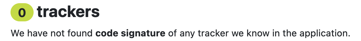
The application is verified by Exodus Privacy Project:

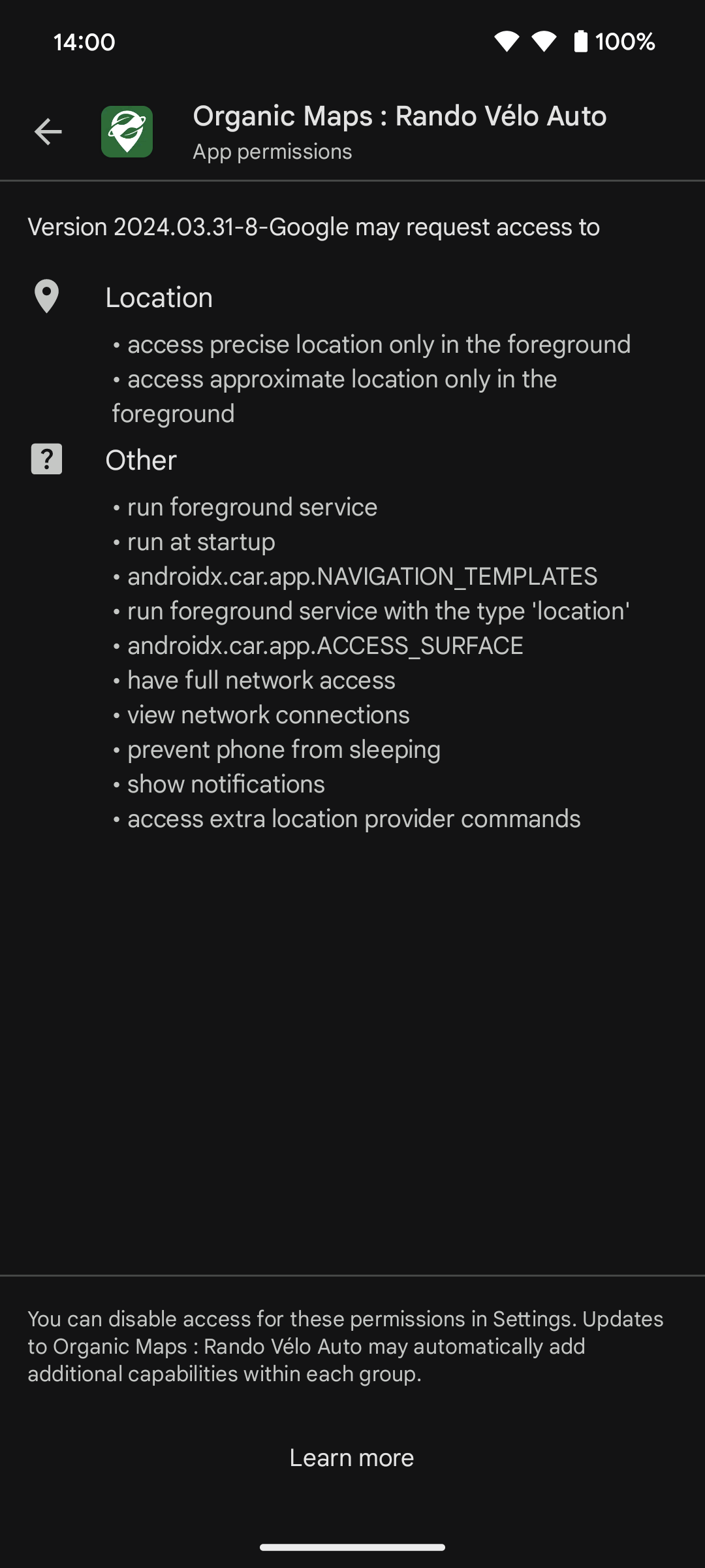
The iOS application is verified by TrackerControl for iOS:
![]()
Organic Maps doesn't request excessive permissions to spy on you:

At Organic Maps, we believe that privacy is a fundamental human right:
Reject surveillance - embrace your freedom.
The app is free for everyone. Please donate to support us!
To donate conveniently, click on your preferred payment method icon below:
Beloved institutional sponsors below have provided targeted grants to cover some infrastructure costs and fund development of new selected features:
Organic Maps is an open-source software licensed under the Apache License 2.0.
How do you square this with Organic Maps being organised as a for-profit entity?